commute
A Dream Map
One of the things that got me fascinated about here in Toronto are bus and subway map routes. It’s never a surprise that I could navigate my way from one spot to the next by just riding and hopping through buses and trains. That’s why my friends here always count on me to be the “navigator” whenever we go on our “little adventures”.
As I was saying, my fascination for these things has led me to come to get to know the bus routes and subway station names much easier especially when I am in a foreign place. For instance, last summer my family and I went for a little vacation to New York and one knows how complex subway lines are there upon first glance. But trust me, once you get to know it, you can easily navigate where you are and where you are headed to, not to mention which subway lines to ride and what not.
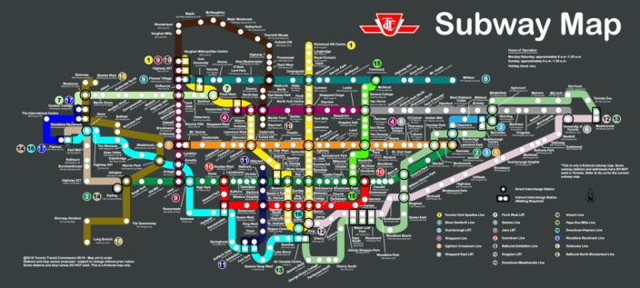
Just recently last week, I finished building up my own subway dream map for Toronto. I included in the map the current existing one, while extending some subway lines and adding some new ones, with their corresponding subway stations. I would think that it would be great if Toronto would get rid of all its buses and focus on building more subways instead.
Environment-friendly? Well, not necessarily. The construction of a subway station and trains can sometimes be considered factors for the destruction of our environment, and can be very costly too when it comes to expenses. But hey, these are just some of my opinions. Tell me what you think about it, as well as the subway dream map I have made. Note that the subway map below is only fictional and that not everything below is real; some subway lines and stations do exist, some are planned, however most are just entirely made up!
View the map up close by selecting one of the shared files below:
PDF: https://drive.google.com/open?id=0B2eAo9vQDug-cUxzaklCT1drX28
PNG: https://drive.google.com/open?id=0B2eAo9vQDug-d1M5NjFVZnFzLUk
– Royalle
Date of Post: 08.18.16
